Showing posts with label hiking. Show all posts

Wednesday, February 13, 2013

Gwern Gof Uchaf, Wales

Gwern Gof Uchaf
  Gwern Gof Uchaf - The Best Campsite Ever

I don't say this lightly

Owned by Sue and Bryan Williams this 750 acres of farmland is a little slice of heaven. The property is situated near Llyn Ogwn along the A5 halfway between Capel Curig and Bethesda.

Camping is £5 per adult per night

Website: http://www.tryfanwales.co.uk/

More info to come!

Tryfan from our tent

 
Sue & Bryan's House


Sunday, February 10, 2013

Corbin Cabin

Corbin Cabin
Nicholson Hollow
The Potomac Appalachian Club runs and owns several cabins scattered along the Appalachian Trail (see map here). These are all mostly primitive cabins with no running water or electricity. Most also require travel on foot to and from the cabin. Reservations can be made by calling (703) 242-0315 Mon-Wed 7-9pm or Thurs-Fri 12noon-2pm. Reservations are a two night minimum and the keys are either mailed to you or made available for pick-up at headquarters at 118 Park ST SE, Vienna, VA 22180. For more information on these cabins check out the PAC's information sheet.

So a friend of mine researched the PAC cabins and booked Corbin Cabin in Shenandoah National Park for a group of 9 of us for a weekend. This specific weekend ended up being very very cold with weather announcers over using the phrase "inclement weather." Unfortunately, the phrase "inclement weather" usually leads to Shenandoah NP closing the entirety of Skyline Drive. Even more unfortunately for us, this meant that the 1 mile hike from Skyline to Corbin was no longer an option and that the 4 mile hike from the Old Rag parking lot was our only option. This would have probably been fine if we had actually gotten on the 4 mile hike to begin with, but I read the map wrong and we got on Corbin Hollow Trail instead of Nicholson Hollow Trail. So the moral of this story is: look at your map before getting on the trail, i.e. "don't be stupid."
So we parked our car in the Old Rag parking outside of the park and hiked up to the upper lot, in the process completely missing the trailhead for Nicholson Hollow Trail which we passed up on the right (in retrospect, there is a large sign for it). So near the Old Rag Fire Road we hopped onto Weakley Hollow which connected us to Corbin Hollow Trail (which was the wrong one). Not only was this the wrong trail, but it added at least 2-3 miles onto our hike and involved an elevation gain of about 3,000 ft thanks to the nearby Robertson Mountain Trail (circled in red on the map). All in all, it was a very cold (about 18-19 degrees) and very steep hike. It took us from about 9am-1pm, but our packs were heavy and we weren't prepared for the length and elevation gain.
River Crossing

The following day hiking back we took the correct trail (Nicholson Hollow). This follows Hughes River so it is fortunately very flat, but there are at least 5-6 river crossings (green arrows on the map). In the summer or spring with Keens this would be no problem, but it was snowing and February (and the water was quite high), so a slip into the water would have been less than pleasant (and potentially dangerous). Also, crossing streams on uneven snow and ice covered boulders with 30+ lb packs on is not easy. All this being said, we did a fairly decent job and only got our feet wet [A quick tip, if you find yourself crossing streams in the winter with only one change of socks on hand, duct tape and trash bags make very good boot/tennis shoe liners]. 


Friday, August 26, 2011

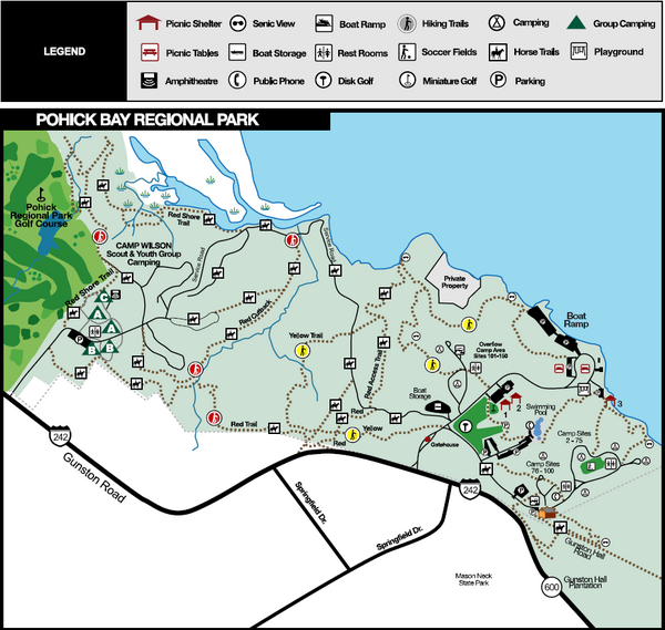
Pohick Bay Regional Park

I have only been here once to put in my newly bought kayak with a friend. It's the perfect park for boating as it's mostly water oriented. You can rent canoes, kayaks, paddle boats and jon boats on weekends (March-October). It also offers group camping, hiking, fishing, picnic areas, miniature golf, large play area for children, and swimming (it boasts one of the biggest outdoor freeform pools on the east coast). The hiking trails total 8.5 miles and there are specific bluebird trails that detour to bluebird boxes so you can check on the park's conservation efforts The waterpark is open May-September.


Official Website


Pros: Perfect for boating. Lots of water routes. Close to DC.
Cons: Some visitors have complained about the cleanliness of the cabins.
Tips: Get a kayak. You'll thank me.
Rating: 4/5

Wednesday, August 24, 2011

Fountainhead Regional Park, VA

 This park lies along a tributary of the Potomac: the Occoquan Reservoir. The marina and parking opens at 6am and there is a bait/tackle shop nearby as well as boat rentals (kayak, canoe, or rowboat). Fishing is allowed with a license (though I've heard it's not superb). Fountainhead also boast an 8 mile mountain biking trail (you can call 703-250-9124 anytime fore trail conditions). Picnic areas are located near the marina and along some trails. The hiking here is beautiful - sometimes hilly, but not difficult unless you decide to portage your kayak by climbing over the dam (not recommended and most likely illegal). The 17.5 mile Bull Run Occoquan Trail begins in Fountainhead and winds through Hemlock Regional Park before ending in Bull Run Regional Park so there's loads to explore.


This is my favorite spot for kayaking due to its size and its proximity to the DC area. It's a quiet and beautiful area with gorgeous homes along the water.

Website

Driving directions (it's good to have several options since 95-South is usually a beast to drive on)

Pros: Easy access off of 95-South (if traffic is actually moving), absolutely beautiful
Cons: Crew teams row along the Occoquan so keep your ears and eyes open, they're fast! Bathrooms are often closed in off season.
Tips: Don't portage your boat over the dam
Rating: 4/5

Westmoreland State Park, VA

Westmoreland State Park takes up 1,311 acres along the Potomac River in Virginia. It boasts 133 camping sites (electric and standard) and several cabins. The waterfront is perfect for fishing and picnics and gets quite crowded in the summer. There are no designated swimming areas in the Potomac itself but the park has a pool available in the summer. Bald eagles are known for nesting within the park and many campers scour the riverside looking for elusive sharks teeth.There are several small hiking trails (the longest just under 2.5 miles) that are ideal for children. I've camped here once for a quick weekend get-away and found the sites well-wooded though a little close together. Since the hiking trails are minimal and swimming isn't technically allowed I would recommend bringing a canoe or kayak as it's proximity to the Potomac is perfect for boating. Paddleboats can be rented Memorial Day through Labor Day and powerboats are permitted as well. Next time I go I'm bringing my kayak for sure.

 
Pros: Beautiful scenery and wildlife. Right along the Potomac River.
Cons: No swimming in the Potomac. Short hiking trails.
Tips: Bring your boat.
Rating: 4/5


Thursday, August 18, 2011

Sneak Peak

Some recent Scotland hikes:

Part of the West Highland Way near Loch Lomond


Arthur's Seat overlooking Edinburgh


More to come!

Wednesday, August 3, 2011

Northern Wales

Here's the brief run-down of my recent trip to Snowdonia National Park in Northern Wales. I'll include more details later about routes, campgrounds, etc. Enjoy!

We arrived in Conwy and toured around the town and castle for a while before heading to a pub outside the city for some lunch. We must have lounged there for a good 2 hours talking to locals and staring at our newly purchased Snowdonia map before we decided to trek over Conwy mountain to get to some ambiguous campsite the map had shown. We hiked said mountain and were awarded with stunning views from the top. Our decent was was a bit spontaneous (and included  wild blackberries) and we stumbled out of some evergreens to find that  we were practically on top of a campsite with hot showers. Sweet as. Ran  up and down the nearby beach at sundown and laughed at our drunken  neighbors before calling it a night.


Caught the bus into Llanberis the following day. Llanberis is a dream: more outdoor stores than restaurants, sweet cafés, and climbers/bikers/hikers everywhere. We were pretty stoked. After buying some stove fuel and people watching (we definitely were not oggling over climbers) we got some hiking advice from a friendly store clerk and hiked down the road towards our next campsite. Explored a castle and sketchy cave on the way and got to catch the tail end of the Snowdon Mountain Run after playing around a stream for hours. The second campsite was even more glorious, nestled in a farm pasture in a mountainous basin. Beauty all around.


Caught the bus to Pen-Y-Pas the next day to hike the Snowdon Horseshoe. Conditions were perfect, which is rare. We met a lady later in the trip that told us out of summitting Snowdon 15 times she had only seen the view from the top once. We got a cloudless day with perfect blue skies.  We hiked Crib Goch which is easily the most bad ass thing I've ever done or ever will do.  Pardon my french but I think I deserve the term after straddling, shimmying, and scrambling over a sharp mountain ridge with 1,000 foot drops down either side. It was a bit ridiculous and completely surreal. Maybe the fact that it  was so surreal kept me from contemplating my immanent death, but I made  it through with only a few blisters, bruises, and a sunburnt nose. We  summitted Snowdon with the rest of the world (there is a train and café at the top).  I heard a fellow hiker mention that there should be a fenced-off area  for Crib Gochers - I agree. We were going to finish on the "easy route"  but got a bit off track and finished off with the twin peaks instead - a  walk in the park compared to Crib. We caught the last bus back to the  campsite and tried celebrating at the local pub but I fell asleep after  my steak & ale pie and single pint so we called it a night.


The next day Theresa wanted to climb more mountains. Instead we tramped into Llanberis again and passed out on bean-bag chairs after a full Welsh breakfast at Pete's Eats (I highly recommend their black pudding and the turquoise bean bag).
We woke up and ate some more (I also highly recommend their chocolate cake) and consulted the map. Once we had pinpointed "a green looking area with waterfalls" we jumped on a bus bound to Betws-y-Coed and camped (slightly illegally) at an RV park that night. All legalities were solved in the morning. Not gonna lie - sometimes it pays to be an innocent looking girl. Don't know if it's a fair trade off with being able to pee standing up, but ya can't have it all.

Hiked up to Swallow Falls in Betws-y-Coed. Ate more wild blackberries. Ruined some scenic photos for tourists (how were we to know our sunbathing was blocking the view? It's not like we were lying directly on top of the waterfall... oh wait) Ate more sardines and paté (one of the many benefits of hiking in areas with no carnivorous predators) and that was that.


On to Ogwen Valley -my favorite campground by far. We set up tent on a hill away from the other travelers and it felt like we had the place to ourselves. We also had a fire right, which was convenient considering our fuel depleted halfway through our noodle dish. Weather was gorgeous when we showed up but quickly deteriorated the next day. We planned to hike all the way to Tryfan via Glyder Fawr and Glyder Fach but after picking our way carefully up the first peak (we could hardly see cairn to cairn in the fog and the ascent was all scree) we couldn't see any sign of the trail at the top. We sat cold, wet and huddled in a small outcropping rationing a pasty while contemplating life, love, and lousy compasses. We decided to turn back, and though feeling glum and defeated we soon met other hikers that had similar difficulties in the fog. Made some friends on the descent and found our way back to the warden station were we loaded up on hot chocolate. Spent the rest of the day trying to warm up in our sleeping bags. Thankfully the sun came out enough to partially dry some of our clothes before bed.

Back to Conwy the next morning. Ate another Welsh breakfast and hiked along the seashore. Dinner of fresh mussels and wine near the harbor. Serenaded by the Once soundtrack from a nearby sailboat (owned by a juggler with dreadlocks- we should have been friends).

Wales, Wales, Wales. Someday we'll meet again methinks.

Thursday, January 27, 2011

White Oak Canyon, VA

A cold December hike in Shenandoah National Park complete with frozen waterfalls!


Our route: White Oak Canyon/Cedar Run loop 
Map: White Oak Canyon Area  
Park website: Shenandoah National Park 
Great trail info: Compass Points

Thursday, November 25, 2010

Cerro Chato and La Fortuna, Costa Rica


Cerro Chato
Dormant volcano near the district of La Fortuna (Costa Rica, South America)
Terrain: 3,742 ft steeply uphill with scrambling required
Duration: 4-6 hours (depending on torrential downpour)
Price: $10 (pay at the Green Lagoon)

Hiking Cerro Chato is not for the faint of heart nor the easily winded. It is an exhausting uphill climb often involving hands and feet (think a literal jungle gym). If you start in the nearby district of La Fortuna and your budget excludes unnecessary taxis you tack on an additional uphill climb to get to the ranger station before even beginning the hike. Bring lots of water and some trail bars. I guarantee you will get hungry, thirsty, and very tired before making it back downhill. Trail maps are available at the ranger station at the entrance to the park, but they sell tickets to the waterfalls alone. For the Cerro Chato trail entrance walk up the steep driveway that you first passed on your right on the way to the ranger station. The Green Lagoon Lodge is at the top of the driveway which is where you will sign-in and pay the entrance fee. Most hotels and tour companies will convince you that you need a tour package or guide, but honestly there is only one way up the mountain and the path is rather obvious thanks to frequently dispersed signs.

Though this strenuous hike is rewarded with the potential view of crater (1,600 ft wide and filled with a lagoon) you can only see said-lagoon on clear days which are few and far between around La Fortuna (thanks to the nearby cloud forest, Monteverde). But hey, if it weren't for the rain it wouldn't be a rainforest, so quit complaining! For best views get started as early in the day as possible and visit during dry season (December-April). It rained steadily for the entire 6 hour hike when we visited in November and the lagoon was hidden under a dense blanket of fog. Once at the top of the dormant volcano there seem to be several trails leading down to the lagoon which are incredibly steep. Just remember, when hiking in a crater what goes down must come up - don't go descending any hill that is too difficult to climb back up. For some more info here is another helpful article about the Cerro Chato hike with some great photos.

Though we reached the trailhead to Cerro Chato via La Fortuna, you can access another trail up the dormant volcano through Arenal Volcano National Park near the Arenal Observatory Lodge. Check these reviews for details about the other trail.


Waterfalls
Terrain: 1/4 mile steep downhill (with stairs)
Duration: 35-50 minutes
Price: $10 (pay at the ranger station)


The smaller waterfall in La Fortuna


The La Fortuna Waterfall
Height: 150 feet


More information from Arenal.net

Friday, April 30, 2010

Matthews Arm, Shenandoah National Park, VA

Mile 22.1 of Shenandoah National Park

I have camped here 4-5 times now and I thoroughly agree with Bill Bryson’s feelings in his book “A Walk in the Woods” when he stated, “Shenandoah National Park is lovely. It is possibly the most wonderful national park I have ever been in, and, considering the impossible and conflicting demands put on it, it is extremely well run. Almost at once it became my favorite part of the Appalachian Trail.” (By the way, Bryson’s book is definitely worth a read if you have any inkling towards hiking/camping or have the slightest appreciation for humor). Matthews Arm is one of the three main campgrounds in the park. Big Meadows is the biggest and most popular (it has showers), but because of this it often fills up the quickest on weekends with lovely weather. Loft Mountain is too far a journey south through the park for my humble little Corolla. Therefore, Matthews Arm has been the campground of choice for most of my Shenandoah trips. It is well situated for anyone wanting to do a good deal of hiking. Some of the hikes are a bit of a drive from the grounds, but there are a few that can be accessed by foot from the site. Like I mentioned, Matthews Arm has no showers, but there is access to potable water and toilets/sinks (the real flushing kind too, what a treat!).
According to reports, “Shenandoah is said to have the highest density of black bears anywhere in the world – slightly over one per square mile” and I believe it. I’ve seen at least one black bear on each of my visits (except for the abbreviated trip to Big Meadows in early March) and I once saw three during a two day trip. Needless to say, don’t ignore the bear-factor in your planning. All food needs to be properly stored in a bear proof container, disposed of in a labeled campground dumpster, or you can take the lazy approach and shove it in your car during the night (I have often employed this tactic with dirty dishes after dark). The end result of this last tactic is usually a car smelling of pancakes and chili for the ride home, but at least the bears weren’t catching whiffs of this delightful smorgasbord downwind while you slept unawares.
A word of encouragement for the ursaphobic (I made that up): In my 4-5 camps at this park I have had no up-close encounters with bears . I have headed all park warnings and kept all food, dirty dishes, and food stained clothing in the car at night and that seems to have done the trick. I’m not promising you won’t have an encounter yourself, I’m just saying there are things you can do to avoid said-face-off. In fact I’ve had more instances at Hickory Run than here – but then again I camp at Hickory run far more frequently . For more bear-avoiding tips check this out: Backpackers.com.

Major Pros: AMAZING hikes nearby. This is the closest campground to Overall Run (the largest waterfall in the park). Shenandoah is beautiful and there are plenty of scenic outlooks of the mountains and valleys.
Major Cons: If you’re into showering daily, too bad. And watch out for bears and snakes.
Tips: 1) Baby wipes work just as well as showers. 2) When hiking in possible “bear territory” make loud noises occasionally: talk loud, clap, sing, etc. A surprised bear is an angry bear, so let them know you’re coming, unless of course they’re hungry and waiting…
Rating: 5/5

Thursday, August 13, 2009

Beaver Pond Campground (Harriman State Park, NY)


If you're looking for a quiet weekend get-away in the Palisades region of New York, I'd suggest a trip to New York City. NYC should be a relaxing picture of serenity during summer weekends since much of the inhabitants seem to migrate to Harriman State Park. No, but seriously, with cramped camping quarters, loud ethnic music playing well past 10pm, and children crying well past midnight (and somehow waking up around 4am with just as much gusto) all that was missing were a few paved roads, pizza-joints, and maniacal taxi-drivers to complete the experience.

At Beaver Pond Campground, most of the sites are quite bare tree-wise and very close together, making the noise factor even more of a problem. I passed ear-plugs around to my entire family the second night of our stay and we all slept like babies (unlike the infants in the site across from us). A truck delivered firewood to sites for a certain fee each evening, but there was no general store to buy ice at unless you felt like walking across the entire campground and beach to the pond-store. Each night we watched an individual across from us attempt to chop firewood with a motion that slightly resembled an arachnaphobe slapping a giant spider while our other neighbors set up their fire pit with a display similar to Stonehenge in wood form perhaps with the hopes that some ancient energy would spread the spark to each independently standing log. I do recognize that as a family we have grown into quite a group of camping snobs and I'm sure that Harriman makes an excellent get-away for the NYC residents (it is only 30 minutes away from the city), but as a whole our stay was quite disappointing and at times verging on ridiculous.

The college-age employees seemed about as useful and knowledgeable as the cast from "Road Trip: Beer Pong," although slightly more sober due to the park's no alcohol policy. The girl behind the counter in the office was helpful enough, but the remainder of the motley crew seemed to loiter aimlessly about the campground flirting with each other and attempting to drive golfcarts down the hiking trails (which were about two shoulder breadths apart, hence the differentiation between "trail" and "road"). Granted, I may be slightly biased here seeing how after driving lost in NY for an hour (no NY state parks seem to be clearly marked, maybe sign-funding was cut due to the economic downturn) we arrived tired and on the verge of hysteria only to be reprimanded by a hot-shot youth for pulling across several parking spots (we had a 9-passenger van with a pop-up camper in tow). According to the numerically-challenged employee, they were expecting 200 reservations in the next 5 minutes (a daunting aspect for a campground of 140 sites) so we were forced to stick to strict traffic regulations in the then-empty parking lot during our 45 second reservation process.

In retrospect, our bad experience was probably as much our own fault as anyone's. The park's strong point is its many hiking trails (over 200 miles, including part of the AT) which we didn't take advantage of since our stay was more of a halfway camping break on our trek to Cape Cod rather than a backpacking trip. The one hike we did go on was pleasantly quiet, challenging, and picturesque though cut short by our decision to visit the pond in the morning. If given the chance again, I would reserve a camping spot in the A or W section (which seemed much more wooded) for a good couple days and spend most of the time on the hiking trails. Researching the trails beforehand would be useful, especially if there are maps online or in the library since they charge for maps at the campground.

Major Pros: Quiet hiking trails: the Appalachian Trail runs through the park, though not too close to Beaver Creek Campground according to employees (might want to look that one up).
Major Cons: Rather unfriendly employees, NYC influx, and golf carts on hiking trails. The campsites are sparsely wooded and cramped, quiet hours not-so enforced, only one water pump for the entire campground, no sinks to wash dishes in.
Tips: If you do camp here, try to get a site in either the A or W section. Both those seemed moderately wooded with much more personal space. Also, ask the Rangers for help/advice, not the college employees. Watch out for deer ticks (I found three after hiking). Lastly, when walking to the restrooms look at the roofs for the respective labels (mens/womens). The doors themselves are not labeled and my dad found himself in the womens room at one point due to this confusion.
Rating:
Park Website