Showing posts with label review. Show all posts

Wednesday, February 13, 2013

Gwern Gof Uchaf, Wales

Gwern Gof Uchaf
  Gwern Gof Uchaf - The Best Campsite Ever

I don't say this lightly

Owned by Sue and Bryan Williams this 750 acres of farmland is a little slice of heaven. The property is situated near Llyn Ogwn along the A5 halfway between Capel Curig and Bethesda.

Camping is £5 per adult per night

Website: http://www.tryfanwales.co.uk/

More info to come!

Tryfan from our tent

 
Sue & Bryan's House


Sunday, February 10, 2013

Corbin Cabin

Corbin Cabin
Nicholson Hollow
The Potomac Appalachian Club runs and owns several cabins scattered along the Appalachian Trail (see map here). These are all mostly primitive cabins with no running water or electricity. Most also require travel on foot to and from the cabin. Reservations can be made by calling (703) 242-0315 Mon-Wed 7-9pm or Thurs-Fri 12noon-2pm. Reservations are a two night minimum and the keys are either mailed to you or made available for pick-up at headquarters at 118 Park ST SE, Vienna, VA 22180. For more information on these cabins check out the PAC's information sheet.

So a friend of mine researched the PAC cabins and booked Corbin Cabin in Shenandoah National Park for a group of 9 of us for a weekend. This specific weekend ended up being very very cold with weather announcers over using the phrase "inclement weather." Unfortunately, the phrase "inclement weather" usually leads to Shenandoah NP closing the entirety of Skyline Drive. Even more unfortunately for us, this meant that the 1 mile hike from Skyline to Corbin was no longer an option and that the 4 mile hike from the Old Rag parking lot was our only option. This would have probably been fine if we had actually gotten on the 4 mile hike to begin with, but I read the map wrong and we got on Corbin Hollow Trail instead of Nicholson Hollow Trail. So the moral of this story is: look at your map before getting on the trail, i.e. "don't be stupid."
So we parked our car in the Old Rag parking outside of the park and hiked up to the upper lot, in the process completely missing the trailhead for Nicholson Hollow Trail which we passed up on the right (in retrospect, there is a large sign for it). So near the Old Rag Fire Road we hopped onto Weakley Hollow which connected us to Corbin Hollow Trail (which was the wrong one). Not only was this the wrong trail, but it added at least 2-3 miles onto our hike and involved an elevation gain of about 3,000 ft thanks to the nearby Robertson Mountain Trail (circled in red on the map). All in all, it was a very cold (about 18-19 degrees) and very steep hike. It took us from about 9am-1pm, but our packs were heavy and we weren't prepared for the length and elevation gain.
River Crossing

The following day hiking back we took the correct trail (Nicholson Hollow). This follows Hughes River so it is fortunately very flat, but there are at least 5-6 river crossings (green arrows on the map). In the summer or spring with Keens this would be no problem, but it was snowing and February (and the water was quite high), so a slip into the water would have been less than pleasant (and potentially dangerous). Also, crossing streams on uneven snow and ice covered boulders with 30+ lb packs on is not easy. All this being said, we did a fairly decent job and only got our feet wet [A quick tip, if you find yourself crossing streams in the winter with only one change of socks on hand, duct tape and trash bags make very good boot/tennis shoe liners]. 


Friday, August 26, 2011

Fiordland National Park, NZ


Lake Gunn Campsite

Location: Milford Road, adjacent to SH 94, 78 km north of Te Anau.
Fee: $5.10 adult/night (no booking)
Accessible for smaller vehicles (we drove up in a sleeper van and got in just fine)
Standard Campsite: 10 tent sites, toilets (portable if I remember correctly), barbacue, picnic tables, only stream water available, no showers

This basic campsite is situated along the Te Anau - Milford Highway in Fiordland National Park on the edge of Lake Gunn.  Melita Peak and Consolation Peak form a beautiful backdrop to the lake. We parked our sleeper van here after driving and hiking through Milford Sound earlier in the day. The shore was quiet and serene with just a few other campers about - gorgeous. 


Milford Sound

 Milford Sound is  absolutely majestic. The Tasmanian sea is the mouth of this fjord on New Zealand's South Island. The sound was deemed the world's top travel destination in the 2008 Travelers' Choice Destinations Awards and is New Zealand's most famous tourist destination. Rudyard Kipling has once called it the eighth Wonder of the World and it's easy to see why. Clouds sometimes hang low shrouding the mountains in gray wisps as they rise mysteriously out of the surrounding waters. Take a cruise around the lake and you'll see waterfall after waterfall cascading down the peaks. With its unusually high rainfall, Milford Sound is the wettest inhabited area in New Zealand and one of the wettest in the world. The area wasn't discovered by Europeans until 1812 since the entryway from the ocean is so narrow. After its discovery it was named Milford Haven after the Welsh explorer's homeland.The Milford Track is a four day hike described by Kipling as "the finest walk in the world." It is a very well-traveled path by now and booking is required before hiking it.


Milford Sound, Fiordland National Park

Deleware Seashore State Park

You know how you will sometimes research a place and after reading several bad reviews think, "Aw, people are just so harsh. It can't really be that bad!"

Lesson learned.

I took a group of friends beach camping one summer in Delaware. My park of choice (Cape Henlopen) had sadly been discovered by the rest of the world so it was completely booked. In my frantic search to find another nearby seashore beach I came across Delaware Seashore State Park. Now, in my past experiences State parks have usually proven to be quite nice and well cared for. The reviews I read mentioned nearby construction and cramped conditions, but I wrote it all off to pansy campers complaining too much and I naively assumed all construction would be halted since it was the height of beach season.


Nope.

There is still ongoing construction at the Indian River Bridge and their website advises visitors to pay close attention to changing traffic patters. The campground itself was very cramped. The tent section had minimal space, little privacy and a scenic backdrop of construction vehicles. How rustic.


There are 146 family sites with water, electric, and sewer hookup, and 37 tent-only sites with no hookups. Electric, water, sewer and showers available April 1 through November 30 and electric and sewer only available year-round. Showers, laundry, ice and soda vending machines are all nearby. It's situated on the Indian River Inlet which is very scenic and made up for the campground a little.


One big issue: NO CAMPFIRES ARE ALLOWED. I'm sure it said this somewhere on the website when we were booking, but it certainly wasn't too obvious. We went into panic mode when we arrived and found it printed boldly on the campground's pamphlet since all we had for dinner was a cooler full of raw hotdogs and hamburgers. They allow BBQs if they are contained, so we bought a cheap one from a nearby WalMart. We may have pushed the envelope a bit far when we tried building a campfire within the BBQ...

Park Ranger: "Hey, there are actually no fires allowed in this park unless they are contained within a BBQ."
My brother: "Oh, but there's a BBQ under there."
Park Ranger skeptically examines the now-minor-bonfire
Park Ranger: "Yeeeeeah, um, I think this should still be put out."

There is a designated area for a group fire at the far end of the campground. The ocean is a short ways on the other side of the bridge and as long as you're facing the water you can't see the cranes and bulldozers behind you.


Pros: Close to the beach
Cons: Construction, cramped quarters, no campfires
Tips:  Reserve earlier and camp at Cape Henlopen
Rating: 1/5


Pohick Bay Regional Park

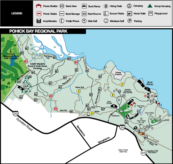
I have only been here once to put in my newly bought kayak with a friend. It's the perfect park for boating as it's mostly water oriented. You can rent canoes, kayaks, paddle boats and jon boats on weekends (March-October). It also offers group camping, hiking, fishing, picnic areas, miniature golf, large play area for children, and swimming (it boasts one of the biggest outdoor freeform pools on the east coast). The hiking trails total 8.5 miles and there are specific bluebird trails that detour to bluebird boxes so you can check on the park's conservation efforts The waterpark is open May-September.


Official Website


Pros: Perfect for boating. Lots of water routes. Close to DC.
Cons: Some visitors have complained about the cleanliness of the cabins.
Tips: Get a kayak. You'll thank me.
Rating: 4/5

Wednesday, August 24, 2011

Fountainhead Regional Park, VA

 This park lies along a tributary of the Potomac: the Occoquan Reservoir. The marina and parking opens at 6am and there is a bait/tackle shop nearby as well as boat rentals (kayak, canoe, or rowboat). Fishing is allowed with a license (though I've heard it's not superb). Fountainhead also boast an 8 mile mountain biking trail (you can call 703-250-9124 anytime fore trail conditions). Picnic areas are located near the marina and along some trails. The hiking here is beautiful - sometimes hilly, but not difficult unless you decide to portage your kayak by climbing over the dam (not recommended and most likely illegal). The 17.5 mile Bull Run Occoquan Trail begins in Fountainhead and winds through Hemlock Regional Park before ending in Bull Run Regional Park so there's loads to explore.


This is my favorite spot for kayaking due to its size and its proximity to the DC area. It's a quiet and beautiful area with gorgeous homes along the water.

Website

Driving directions (it's good to have several options since 95-South is usually a beast to drive on)

Pros: Easy access off of 95-South (if traffic is actually moving), absolutely beautiful
Cons: Crew teams row along the Occoquan so keep your ears and eyes open, they're fast! Bathrooms are often closed in off season.
Tips: Don't portage your boat over the dam
Rating: 4/5

Westmoreland State Park, VA

Westmoreland State Park takes up 1,311 acres along the Potomac River in Virginia. It boasts 133 camping sites (electric and standard) and several cabins. The waterfront is perfect for fishing and picnics and gets quite crowded in the summer. There are no designated swimming areas in the Potomac itself but the park has a pool available in the summer. Bald eagles are known for nesting within the park and many campers scour the riverside looking for elusive sharks teeth.There are several small hiking trails (the longest just under 2.5 miles) that are ideal for children. I've camped here once for a quick weekend get-away and found the sites well-wooded though a little close together. Since the hiking trails are minimal and swimming isn't technically allowed I would recommend bringing a canoe or kayak as it's proximity to the Potomac is perfect for boating. Paddleboats can be rented Memorial Day through Labor Day and powerboats are permitted as well. Next time I go I'm bringing my kayak for sure.

 
Pros: Beautiful scenery and wildlife. Right along the Potomac River.
Cons: No swimming in the Potomac. Short hiking trails.
Tips: Bring your boat.
Rating: 4/5


Tuesday, August 23, 2011

Owens Creek, MD

Owens Creek campground is part of Catoctin Mountain Park and usually opens early May. I've camped here once just to get away from DC and be outside. It served the purpose quite well. The campsites were well wooded and it was fall so there were beautiful leaves everywhere. Aside from nearly being impaled by a large falling piece of dead tree while sleeping in the early morning, it was a pleasant and uneventful day and a half of camping goodness.

Campground information

Major Pros: It is quiet and pretty remote considering its proximity to route 15. A great weekend or one night get-away.
Major Cons: If you arrive after dark its really hard to find wood for a fire, but this is true of all campgrounds.
Tips: Arrive before dark. Avoid falling tree debris.
Rating: 3


Wednesday, February 2, 2011

Precipice Trail -Acadia National Park, ME

"CAUTION: The Precipice is maintained as a non-technical climbing route, not a hiking trail. Attempt this route only if you are physically fit, wearing proper footwear, and have experience in climbing near exposed cliffs and heights. Allow 3 hours for a round-trip climb, Avoid this route during inclement weather or darkness. Stay on trail and do not throw or dislodge rocks onto hikers below. Persons have received serious injuries and others have died on this mountain side!"

     So reads the sign which someone deemed appropriate to place at the summit of Precipice Trail in Acadia National Park, though in my opinion it would be much more appropriate if it were at the parking lot entrance. People travel from all over to scramble up this 1,000 foot nearly vertical trail. The caution sign isn't joking when it states this is not a hiking trail. It consists mostly of rock scrambling, climbing up rungs and ladders, and occasionally shimmying across narrow exposed ledges. Adventurers ascend about 930 feet in only 0.8 mile. It is imperative to check the weather forecast before embarking on this adventure. I strongly advise bringing plenty of water and snacks and not climbing alone. Hardy footwear is essential - you will regret sandals immediately. I went with a group of four and we spotted each other at more technical points which ended up saving me from a potentially nasty fall at one point.

The entrance to the trail is at the Precipice parking area on the Park Loop Road. All trails within Acadia are very clearly marked and a big plus is the free buses that pick up and drop off all around Mount Desert Island. This was particularly convenient to us since we hiked up Precipice and ended up taking the easier route (Beehive Trail) down due to exhaustion. Unfortunately the easier route put us down on the opposite side of the mountain but the handy-dandy Acadia bus system came to the rescue. Pick up a bus service flier at any of the ranger stations.

Be sure to check here for trail closures before planning your visit. Peregrine falcons nest around this trail and conservation efforts involve closing certain areas for their safety.


A few photos from the trail


Though this trail is a beast to hike, the pay off is a breathtaking panoramic view of Mount Desert Island that is well worth the effort.


Thursday, January 27, 2011

White Oak Canyon, VA

A cold December hike in Shenandoah National Park complete with frozen waterfalls!


Our route: White Oak Canyon/Cedar Run loop 
Map: White Oak Canyon Area  
Park website: Shenandoah National Park 
Great trail info: Compass Points

Thursday, November 25, 2010

Cerro Chato and La Fortuna, Costa Rica


Cerro Chato
Dormant volcano near the district of La Fortuna (Costa Rica, South America)
Terrain: 3,742 ft steeply uphill with scrambling required
Duration: 4-6 hours (depending on torrential downpour)
Price: $10 (pay at the Green Lagoon)

Hiking Cerro Chato is not for the faint of heart nor the easily winded. It is an exhausting uphill climb often involving hands and feet (think a literal jungle gym). If you start in the nearby district of La Fortuna and your budget excludes unnecessary taxis you tack on an additional uphill climb to get to the ranger station before even beginning the hike. Bring lots of water and some trail bars. I guarantee you will get hungry, thirsty, and very tired before making it back downhill. Trail maps are available at the ranger station at the entrance to the park, but they sell tickets to the waterfalls alone. For the Cerro Chato trail entrance walk up the steep driveway that you first passed on your right on the way to the ranger station. The Green Lagoon Lodge is at the top of the driveway which is where you will sign-in and pay the entrance fee. Most hotels and tour companies will convince you that you need a tour package or guide, but honestly there is only one way up the mountain and the path is rather obvious thanks to frequently dispersed signs.

Though this strenuous hike is rewarded with the potential view of crater (1,600 ft wide and filled with a lagoon) you can only see said-lagoon on clear days which are few and far between around La Fortuna (thanks to the nearby cloud forest, Monteverde). But hey, if it weren't for the rain it wouldn't be a rainforest, so quit complaining! For best views get started as early in the day as possible and visit during dry season (December-April). It rained steadily for the entire 6 hour hike when we visited in November and the lagoon was hidden under a dense blanket of fog. Once at the top of the dormant volcano there seem to be several trails leading down to the lagoon which are incredibly steep. Just remember, when hiking in a crater what goes down must come up - don't go descending any hill that is too difficult to climb back up. For some more info here is another helpful article about the Cerro Chato hike with some great photos.

Though we reached the trailhead to Cerro Chato via La Fortuna, you can access another trail up the dormant volcano through Arenal Volcano National Park near the Arenal Observatory Lodge. Check these reviews for details about the other trail.


Waterfalls
Terrain: 1/4 mile steep downhill (with stairs)
Duration: 35-50 minutes
Price: $10 (pay at the ranger station)


The smaller waterfall in La Fortuna


The La Fortuna Waterfall
Height: 150 feet


More information from Arenal.net

Monday, October 11, 2010

Gauley River, WV

[review to come]


                         Surfing on the Upper Gauley 


 Thank you River Expeditions for the experience!

Sunday, July 11, 2010

Cape Cod, Massachusetts

[review to come]

Wiley Pond, Eastham

Great Island, Wellfleet


Salt Marsh

Kettletown State Park, Connecticut


Click for Campground Map
Kettletown State Park is situated along the Housatonic River and Lake Zoar in Connecticut and is open May-September. It has 68 camping sites (open or wooded) as well as youth group camping. My family camped here for two nights on our way up to Cape Cod and we enjoyed our stay. It has a fun family atmosphere and seems to appeal to families with young children. As of 2011 possession of alcoholic beverages is prohibited June through September so consider yourself warned. 

The campground consists of 605 acres and offers camping, swimming, fresh water fishing, picnicking and hiking (click for pdf hiking map). The trails are fairly short and easy, though quite pretty - ideal for children. There are cool pools of water and mini-waterfalls back along some of the wooded trails.


Pros: Pretty and wooded. Good for kids.
Cons: Short hiking trails.
Tips:  If you're not camping with children this might not be ideal for you.
Rating: 3/5

Official website 

Friday, April 30, 2010

Matthews Arm, Shenandoah National Park, VA

Mile 22.1 of Shenandoah National Park

I have camped here 4-5 times now and I thoroughly agree with Bill Bryson’s feelings in his book “A Walk in the Woods” when he stated, “Shenandoah National Park is lovely. It is possibly the most wonderful national park I have ever been in, and, considering the impossible and conflicting demands put on it, it is extremely well run. Almost at once it became my favorite part of the Appalachian Trail.” (By the way, Bryson’s book is definitely worth a read if you have any inkling towards hiking/camping or have the slightest appreciation for humor). Matthews Arm is one of the three main campgrounds in the park. Big Meadows is the biggest and most popular (it has showers), but because of this it often fills up the quickest on weekends with lovely weather. Loft Mountain is too far a journey south through the park for my humble little Corolla. Therefore, Matthews Arm has been the campground of choice for most of my Shenandoah trips. It is well situated for anyone wanting to do a good deal of hiking. Some of the hikes are a bit of a drive from the grounds, but there are a few that can be accessed by foot from the site. Like I mentioned, Matthews Arm has no showers, but there is access to potable water and toilets/sinks (the real flushing kind too, what a treat!).
According to reports, “Shenandoah is said to have the highest density of black bears anywhere in the world – slightly over one per square mile” and I believe it. I’ve seen at least one black bear on each of my visits (except for the abbreviated trip to Big Meadows in early March) and I once saw three during a two day trip. Needless to say, don’t ignore the bear-factor in your planning. All food needs to be properly stored in a bear proof container, disposed of in a labeled campground dumpster, or you can take the lazy approach and shove it in your car during the night (I have often employed this tactic with dirty dishes after dark). The end result of this last tactic is usually a car smelling of pancakes and chili for the ride home, but at least the bears weren’t catching whiffs of this delightful smorgasbord downwind while you slept unawares.
A word of encouragement for the ursaphobic (I made that up): In my 4-5 camps at this park I have had no up-close encounters with bears . I have headed all park warnings and kept all food, dirty dishes, and food stained clothing in the car at night and that seems to have done the trick. I’m not promising you won’t have an encounter yourself, I’m just saying there are things you can do to avoid said-face-off. In fact I’ve had more instances at Hickory Run than here – but then again I camp at Hickory run far more frequently . For more bear-avoiding tips check this out: Backpackers.com.

Major Pros: AMAZING hikes nearby. This is the closest campground to Overall Run (the largest waterfall in the park). Shenandoah is beautiful and there are plenty of scenic outlooks of the mountains and valleys.
Major Cons: If you’re into showering daily, too bad. And watch out for bears and snakes.
Tips: 1) Baby wipes work just as well as showers. 2) When hiking in possible “bear territory” make loud noises occasionally: talk loud, clap, sing, etc. A surprised bear is an angry bear, so let them know you’re coming, unless of course they’re hungry and waiting…
Rating: 5/5